Search the Community
Showing results for tags 'map'.
Found 16 results
-
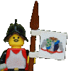
Battlefield Map by Arfelan, en Flickr After eliminating an Emeran army during the Igrian Campaign, Noliron forces seized the capital. The Santriau avoided further conflict until the arrival of the reinforcements that bolstered their numbers. Aleneleon sent part of his army north in pursuit of the Santriau, but then ordered his forces to retreat so he could feign a grave weakness. ---------------------------------------------- Hope you like it. Thanks for watching.
-
Captain Brickleton wanted to know more about the island of Panarium. In the week following their arrival at the future site of Wullham, he sent expeditions out by land and sea to survey the island. Second Lieutenant Berthing of the 18th Hussars set out with another trooper and an Onondaga settler who had accompanied them from Elizabethville. They rode across the island many times identifying key features Most of the island was covered in grassy hills. They noted a total of ten mountains on the island and highlands on the northern half of the island. A medium-sized river flowed from the mountains of the southwest on to the sea. They spotted a few smaller islands offshore. Lieutenant Freeman, a Royal Navy Intelligence officer, circumnavigated the island by rowboat. Accompanied by a soldier of the 26th Foot, they spent a week camping on beaches and sounding the depths to establish the extent of the shallows. They made depth soundings around the island and took a detailed account of all of the inlets and shore curvature. They also were able to make out ten distinct mountains as they made their way around the island by sea. Once back at camp in Wullham, Lieutenant Freeman erected a table on a hill overlooking the sea. He had become close friends with his travel companion from the 26th Foot while conducting the survey. His friend and a second soldier played melancholy background music while Freeman combined the interior details the Hussars had gathered with his more detailed sea records. A detailed map of Panarium OOC: The accordion idea is from the BirdBase build by @Fraunces. Got some new CMF Series 21 minifigs in the mail yesterday and wanted to include the fiddle from violin boy in the third vignette.
-
15 years ago, I moved to California from Germany with my family and it changed my life tremendously. I love it here, so I wanted to make a tribute to the Golden State that highlights some of its best and most recognizable features. This is a three dimensional map of California with a minifig and micro build for each landmark, including Hollywood, Disneyland, Legoland, Death Valley, Joshua Tree Park, Monterey Bay, the Golden Gate Bridge, Yosemite Half Dome, Lake Tahoe, Napa Valley, and Redwood Park. I tried to make it as topographically accurate as possible with all the mountains and valleys. I even included the islands around it. As you can see, it has the recognizable sock-shape of California. Let's take a closer look, starting with the NorCal portion. Here you can see a hiker among some redwood trees, a vineyard farmer harvesting grapes for his wine, and a snowboarder by Lake Tahoe. The bay area is represented by a micro build of the golden state bridge, a hippie, and a seal for Monterey Bay. The SoCal section is comprised of the Hollywood sign with an Academy Award winning actress, the Disneyland Castle, a placemark for Bricks LA (which this MOC was built for), and Legoland California. In the back, you can see a joshua tree and a skeleton, representing Joshua Tree Park and Death Valley respectively. And what would a California MOC be without a surfer dude? This dude is surfing in front of a beach scene that represents all the great beaches in California such as Santa Barbara and Pismo Beach. Let me know what you think in the comments. Thanks for looking and keep on California dreamin'.
-
This is Aoraki Mount Cook, the tallest mountain in New Zealand, built with LEGO. It has a scale of 1:31,250, or 1 plate = 100m, 1 stud = 250m. The vertical scale is accurate. This is determined by the dimensions and height to width ratio of a 1x1 plate. It has approximately 20,000 parts, and weighs about 30kg It is approximately 80cm x 120cm, covering 6 large baseplates, and splits in to three sections to make it easier to transport. During this year, I have built three topographic maps with LEGO. All of them are the same scale, using a 100m vertical resolution and 250m horizontal resolution. The first is of Banks Peninsula and Lyttleton Harbour on the south side of Christchurch, New Zealand (where I live) It covers 6 large baseplates, divides into the 6 baseplates, and contains about 5800 parts. I displayed this at the Southand Brick Show in Invercargill. Unfortunately, not very many people recognised it! My second map was an earlier version of Mount Cook, with less colours, and covering a smaller area. It is built on two large baseplates in one piece. it weighs nearly 10kg, and has over 6000 parts. I displayed this at the Christchurch Brick Show alongside my first map, which was received a bit better. My third map is the big Mount Cook map. I didn't get it complete by the Dunedin Brick show, and continued building it there. I still didn't get it completed by BrickCon NZ in Upper Hutt, and continued building it there as well, completing it at the end of the first exhibition day. It was definitely well received at that show It is now on display in Twizel at the Meridian building. Twizel is where I spent the first 8 or so years of my life, and is about 75km south of Mount Cook (you can see Mount Cook form Twizel on a good day)
-
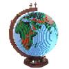
I started a projct on Lego Ideas and i thought i could need some more supporters. Thats why I want to present my project to you. I build with LDD a geographical World Map with different coulors for mountains, snow etc. and I added some animals, because than its more interesting and not so boring. Maybe you would like to support my idea. Here is the link: https://ideas.lego.com/projects/fbda3448-e93f-479a-b737-fa1c4f6e1a9e. I would be very happy if you do so ! I hope this post is in the right forum
-
Hi everyone, I did a map drawing out all the trade routes people used. Trade Map by North White, on Flickr Red is Corrington Green is Eslandola Blue is Oleon Gray is Sea Rats Yellow is Mardier Black is other This shows a basic idea of how ships move in BoBS. The map does not show which direction the ships were going, however, and this is a rough estimate. For example, a ship traveling between Weelond and Nova Terrelli could pass through zone 10 or 12. So, the trade routes could be comepletely different. Also, I only recorded ships that had their location registered in two KPAs, so the FTA fleet is not in this analysis. Additionally, if a ship left from a port and returned to it, I have no idea where it went, so it was not added to the map. Let me know what you guys think, and I hope this helps people out.
-
Hello everyone! I am MovieMocs and I am new to the forums but I would like to share some of my favourite mocs I've created and I'd love some feedback to help make me a better builder. The first moc I will be posting is this one. A 3-D map of middle earth. It features these famous landmarks: Barad Dur Mt. Doom Minas Tirith Helm’s Deep The Iron Hills The Lonely Mountain/Smaug Laketown Mirkwood/Spiders High Pass Rivendell Weathertop Gandalf’s Fireworks Hobbit Hole Dol Guldur Please leave as much feedback as possible. Thanks so much!
-
Hello together, I have build a LEGO world map for our living room. Maybe you find it interesting. You can find a detailled description with images on mocpages and on my blog. I would really like to hear your feedback!
-
Hello everyone! I am MovieMocs and I am new to the forums but I would like to share some of my favourite mocs I've created and I'd love some feedback to help make me a better builder. The first moc I will be posting is this one. A 3-D map of middle earth. It features these famous landmarks: Barad Dur Mt. Doom Minas Tirith Helm’s Deep The Iron Hills The Lonely Mountain/Smaug Laketown Mirkwood/Spiders High Pass Rivendell Weathertop Gandalf’s Fireworks Hobbit Hole Dol Guldur Please leave as much feedback as possible. Thanks so much!
-
UPDATE! After working with the creator of swgalaxymap.com, I have created a jpeg snapshot of his amazing map. We have been given permission to use if for SoNE. I plan to add more planets in the future, but for now you can get used to seeing the universe in more detail! And, if you want to find a specific planet, just go to the map website and find it there. The grid matches between the two maps. The old map is in the spoiler: ________________________________________________________________________________________________________________________________ Bothawui - Located in the Mid Rim, Bothawui has three moons and is home to the Bothan species. This cosmopolitan planet has a temperate climate and its terrain consists of mountains and ridges separated by deep, wide valleys inhabited by dangerous wildlife, as well as plains, forests, and urban areas. While Bothawui is famous as a major hub for information trafficking, it also has industrial centers, grain farms, and mines. There are many different styles of buildings on Bothawui, but it’s largest population centers are known for their stone towers. While officially a part of the Empire during the Galactic Civil War, the Imperials maintained little presence on the planet. A figure-head governor and a small contingent of stormtroopers was the only outward sign that the world was under supposedly Imperial governorship. Both the Imperial and Rebel Alliance intelligence services apparently decided to let the planet serve as neutral ground, where they could both spy on one another with no open conflict. (Taken from http://starwars.wiki...m/wiki/Bothawui and Star Wars - The Essential Atlas) Commenor - Located just outside of the Core Worlds, Commenor has two moons. It is a major trading outpost and spaceport and is known for its high status and wealth. The University of Commenor is most notable point of interest though the planet does also have many notable cities, mountains, oceans, deserts, and canyons. During the beginning of the Galactic Civil War the planet was under control of a private Imperial Citizen, Dunkler Klerus. (Taken from http://starwars.wiki...m/wiki/Commenor and http://holocron.swco...tle_of_Commenor) Corellia - One of the Core World plantes, Corellia has three moons and is home to humans, Selonians, and Dralls. It is the capital planet of the Corellian system, which also includeds Selonia, Drall, Tralus, and Talus. Collectively, the planets of the system were known as the Five Brothers. As the largest planet and the closest to Corell, Corellia is often called the "Eldest Brother" or the "Eldest." Corellia's surface is extremely temperate, dominated by rolling, thick forests, lush farmland, crystal swamps, golden beaches, and large seas. Snow-covered mountains dominate part of the landscape and it is rumored that there are many deep underwater caverns. There is also a tunnel system developed by the Selonians that runs under most of the planet. Coellia remains largely rural and undeveloped, with small villages and farming communities comprising the bulk of urban development. This is due to its main industry being its massive orbital shipyards. The largest cities are Coronet—the planetary capital, the tourist haven of Kor Vella, the double-city Tyrena, and the mountain hamlets of Doaba Guerfel and Bela Vistal. With the declaration of the New Order, Diktat Dupas Thomree made a deal with Palpatine: Thomree could govern Corellian Sector as he wished (mostly free of Imperial mandates) as long as he paid taxes, war matériel, and homage to the Emperor. Diktat Dupas Thomree died in 2 BBY. He was replaced by Daclif Gallamby whom was little more than a puppet of the Imperial Governor. Although officially under Imperial control Corellia kept its own security force known as Corellian Security Force or CorSec for short. CorSec became famous for its rigid adherence to law and order in part because of Corellia’s equally famous smugglers like Han Solo. Following the abandonment of Massassi Station, the Rebel Alliance established a base on Corellia in 1 ABY before moving on to Hoth. (Taken from http://starwars.wiki...m/wiki/Corellia and Star Wars - The Essential Atlas) Dantooine - Located in the Raioballo sector of the Outer Rim, Dantooine has two moons and is home to the primitive Dantari race though its sentient population consisted primarily of simple Human farmers. A pleasant olive, blue, brown, and purple colored world of grasslands, savannahs, rivers and lakes, Dantooine hosts a small population spread amongst single-family settlements and small communities with large land holdings. Dantooine has several continents. There is an equatorial one that is connected to a larger northern one and a south polar one by slender land bridges, as well as a disconnected north-eastern continent. It is remote from the bustle of the galactic trade routes and the few colonists who live there maintain individual family estates largely isolated from each other. Some of the local fauna consists of spiky blba trees and ocher plains. (Taken from http://starwars.wiki.../wiki/Dantooine and Star Wars - The Essential Atlas) Felucia - Located in the Outer Rim Territories, Felucia has two moons and is home to the tribal Felucians. A largely unsettled terrestrial jungle planet it has a hot and humid atmosphere and significant water resources beneath a surface irradiated by ultraviolet light. The planet’s surface has an almost hallucinogenic quality. The larger-than-life flora is gooily translucent and saturated with every rainbow hue in the visible spectrum. Felucia has a diversity of bizarre plants, fungi, and animals which were almost rubber-like and translucent. When the sun shines, the environment glitters like multicolored glass. Most of Felucia is entirely covered by a humid, fetid landscape of huge fungal forests including phosphorescent lichens, explosive spore shooters, toxic puffballs, and carnivorous blossoms. Felucia’s animals are even odder, often compoased of a see-through, boneless musculature that makes them resemble dollops of gelatin including native gelagrubs, immigrated acklays, and a prodigious sarlacc. Felucia would not support large-scale colonies and any new arrivals established hard-fought, scattered settlements on the surface. These small settlements eventually developed into commercially administered cities like Kway Teow, Har Gau, Jiaozi, and Niango, pushing the native jungle-dwelling Felucians to retreat into the wilderness. Some native Felucians utilized subterranean caverns while others socialized in farming communities based around Nysillin crop. Although the Empire later maintained a presence on the planet through the Galactic Civil War, Felucia became heavily trafficked by crime syndicates. (Taken from http://starwars.wikia.com/wiki/Felucia and Star Wars - The Essential Atlas) Fondor - Located in the Freeworlds portion of Tapani sector, Fondor has six moons and is home to the Fondorians who were baseline Human, but with no hair and purple blood. Fondor itself was completely industrialized eons ago, and its surface scabbed with excavations, factories, cooling towers, steam tunnels, and offices. The planet also housed hectares of laborers' barracks for the dockworkers whose jobs were overhead in the shipyards. However, most of the surface factories are autonomous, controlled by great droid brains and billions of worker droids. The capital city is Fondor City. Fondor is famous throughout the galaxy for its extensive orbital shipyards and spacedocks, outclassed only by those at Corellia and Kuat. The Fondor Shipyards were associated with the Techno Union prior to the Clone Wars, and were sufficiently vast to construct the Executor, Darth Vader's Executor-class Star Dreadnought. (Taken from http://starwars.wikia.com/wiki/Fondor and Star Wars - The Essential Atlas) Hapes - Located in a nebula known as the Transitory Mists, Hapes is the capital of the isolationist, female-ruled Hapes Cluster and is home to the Hapans, a near human race. It is also the administrative capital of the Hapes Consortium. It is a beautiful world of lush forests, soaring mountain ranges, and impeccably clean cities and factories. Hunting is strictly regulated by the Queen Mother, as is Hapes’s robust fishing industry. Much of the surface was untouched due to the Hapan love of beauty, with Hapans preferring to stay in one of the few small, neat cities located on the planet’s surface, or Ta'a Chume'Dan, the capital city of Hapes. The Hapans were ruled by the Queen Mother. The title of Queen Mother was hereditary, passed down from mother to daughter. If the Queen Mother failed to have daughters, the wife of the firstborn son became Queen Mother. However, to be in the line of succession meant both the Queen Mother and her heirs had to avoid constant attempts on their lives by jealous relatives who vied for the throne themselves. In addition to the Queen Mother, there were also representatives from each Consortium member planet at the Hapan Royal Court. Their main purpose was to vote on matters of importance and to give updates on any political and social conditions of their home planets that may require the Queen Mother's attention. The Queen Mother had the final say on everything, and her word was considered law. Hapan culture, at least among the upper classes, was based on assassination attempts and struggles for power. Most members of Hapan nobility or royalty would think nothing of manipulating and/or arranging the death of one of their own if it would advance their own cause. Due to the matriarchal society of the Hapes Consortium, men were often treated as second class citizens. Hapan males were used mainly for breeding and thought of as little more than an accessory. The Hapan people had a deep (some would say neurotically so) love of beauty. If a person, especially the heir to the throne, was blemished or deformed in any way, it was considered a fate worse than death. Surrounded by shimmering nebulae, and with seven moons in the sky after sunset, Hapes never knew the darkness of true night, and the Hapan people had relatively poor night-vision. Hapes, via the Consortium, was vastly wealthy, with treasures such as rainbow gems and guns of command fetching high prices on both legal and illegal markets. Even though businesses could operate on any of the 63 member planets of the Hapes Consortium, Hapan law dictates that all major financial and business transactions must be conducted at Ta'a Chume'Dan, the capital city of Hapes. (Taken from http://starwars.wikia.com/wiki/Hapes and Star Wars - The Essential Atlas) Kuat - Located in the Core Worlds, Kuat has two moons and is home to a mostly human population. It is a terraformed planet of forests and plains. Early in its history rule of the planet fell to the Ten, a consortium of the richest merchant families. The Ten were the ones who terraformed Kuat’s surface into terraced parkland and built the orbital rings that give the system some of its fame. It is best known as the home of Kuat Drive Yards. These famous shipyards, used to build ships for both the Galactic Republic and later the Galactic Empire, circled the planet for thousands of kilometers. The Kuati have a matriarchal society with four castes: the elite aristocracy; the wealthy middle class; the (native) working class; and the lowly off-world laborers. These divisions led to peculiar bredding quirks including the telbun – a physically perfect male specimen offered by a merchant family to the father the offspring of a female aristocrat, yet possessing none of the rights of the father. (Taken from http://starwars.wikia.com/wiki/Kuat and Star Wars - The Essential Atlas) Mon Calamari / Dac - Located in the Outer Rim, the aquatic planet Mon Calamari has one moon and is home to a wealth of sentient species: the Mon Calamari, the Quarren, the Moappa, the Amphi-Hydrus, and the Whaladons. The native species referr to the planet as Dac while the non-indigenous refer to it as Mon Calamari or Mon Cala. The oceans of Mon Calamari contain a massive biodiversity of aquatic creatures. Only island chains break the surface of the shallow oceans, with most of the 27.5 billion inhabitants living in floating megalopolises or pressurized bases on the seafloor. The planet is surrounded by the impressive Mon Calamari Shipyards. (Taken from http://starwars.wikia.com/wiki/Dac and Star Wars - The Essential Atlas) Sullust - Sullust is located in the Outer Rim Territories. It is the homeworld of the Sullustans and headquarters of the galaxy-spanning SoroSuub Corporation. All of Sullust is composed of multicolored rock, veined by lava channels. The world is volatile with hundreds of active volcanoes, producing a noxious, toxic atmosphere and intense electrical storms. These conditions, combined with the planet's rich mineral deposits, cause the native Sullustan inhabitants to live in underground caves. The underground caves are humid and cool, with a diverse biosphere supported by underground lakes. The planet was once known for its podraces. (Taken from http://starwars.wikia.com/wiki/Sullust and Star Wars - The Essential Atlas) Ord Mantell - Located in the Bright Jewel Cluster in the Mid Rim, Ord Mantell has two large moons and thirteen other satellites orbiting the planet. This collection of natural wonders made Ord Mantell something of a tourist attraction, despite its seedier side. It was also the homeworld of the Mantellian Savrips and Mantellian flutterplumes, whose sentience was largely unnoticed or ignored. Mountains and islands are the distinct features of Ord Mantell's terrain. Almost every land mass on the planet is dotted with mountain chains. Its population is clustered on the arid equatorial continents amid low mesas and flat plains. Coastal cities, including the capital Worlport, are glittering baubles that entice visitors to drop their money at casino tables. The urban outskirts are far less glamorous, with junkyards that stretch for hundreds of kilometers and strip mines that gush oily smoke. Ord Mantell's continent boasts a sprawl of cities along its southern shore and it is this part of Ord Mantell that many spacers regarded as a safeport, famous for casinos and for tourists, of which it attracted almost one billion annually. Other metropolitan areas lacked address markings and were considered not intended for outsiders. The thinking behind this was that if you don't know where you're going, then you don't belong here. Outside of the urban sprawl, the narrow equatorial band of starports and the volcanic islands, Ord Mantell remained largely rural and low tech. Its extreme reliance on fossil fuels kept the planet quite barren, huge robotic coal yards remained to fuel the planet's cities and an immense junkyard littered a large portion of the planetscape Ord Mantell lost its strategic significance over time due to the expansion of new trade routes, but the presence of military-quality starship yards and docks brought a thriving civilian cargo trade to the world. Eventually it became a haven for mercenaries, exiles, murderers and smugglers. Ord Mantell’s non-native population comprises a true melting pot, with Rodians, Rybets, Devaronians, Arconans, humans, and a thousand other species intermingling, and no group numbering more than five percent of the population. (Taken from http://starwars.wiki...iki/Ord_Mantell and Star Wars - The Essential Atlas) Ring of Kafrene – Located in the galaxy's Expansion Region between Takodana and the Corellian Trade Spine, the Ring of Kafrene is an asteroid belt in which a great mining colony was constructed in the days of the Old Republic. During the civil war, it is controlled by the Galactic Empire and home to a great number of different beings, looking to make a living under difficult circumstances. The Empire's grip around the system is tight, but the sheer amount of ragtag individuals crowding the streets of the colony makes it hard for authorities to keep a close eye on shady business being conducted in the back alleys. One can stumble upon a lot of useful information in this colony if asking the right questions – and quickly be silenced if asking the wrong ones. (Taken from http://starwars.wikia.com/wiki/Ring_of_Kafrene, http://www.swgalaxymap.com/ and Rogue One: A Star Wars Story ) Eadu - It has stormy weather conditions and is home to the Imperial Kyber Refinery. Perhaps the planet's natural resources offer kyber crystals as well? Wobani - Imperial prisoners are brought here and it looks like it uses old war gear from the clone wars as well, allowing players to mix PT-styled builds into their creations for this planet. It practically begs to display imprisonment, escape and rescue scenarios going on between Imperials and Rebels. Scarif - After the utter annihilation of the Imperial data archives and the planetary shields were destroyed, the Empire probably gave up on the planet, military-wise and had their fleet move out from the sector, which makes this even battle ground for both parties. Even though a part of the planet's surface has been devastated, the rest is still intact and probably inhabited. Jedha - I think there's enough evidence to speculate things go on outside the city from Saw's whole underground network. The alliance regarded him and his forces as a terrorist army. Who knows, what or who else is outside that city? Tunnel Networks, smugglers, Guavian Death Gang, Kanjiklub? It is the imagination's limit until more (if any) source material comes out. Lah'mu - This was covered a little bit in the book prequel too. Though barren, you did draw the parallel to Tatooine. Plus Again, Saw had something to do with picking the location. Could be more rebels in hiding. Personally, I found the planet fascinating.
-
It had been hours since Samarkand lost sight of the Black Spire forces tracking him. Night was descending on the swamp and Samarkand was desperately lost. The wound in his leg throbbed, blood still dripping from the badages. He had to stop. Those clumsy fools have about as much luck finding me as I do of getting out of this swamp alive, Samarkand thought to himself. Besides, there are worse things roaming about when night falls in Nocturnus. Samarkand stopped his horse in a small clearing a good ways off the path. He needed rest. He tried not to think about Hexana, her lifeless body no doubt desecrated by the Black Hand soldiers. Hexana had been one of Nocturnus' best spies. Her death would be a serious blow to the Resistance. More poignantly, she and Samarkand were lovers. Their love grew even when they found themselves on opposite sides of the Civil War - that is, before Samarkand followed Anfaulglir into rebellion. None of that mattered now. Suppressing his hatred and torment, Samarkand knew what he had to do: get the map to Shadowmere and the leaders of the Nocturnian Resistance. He did not know what the map pointed to, but he knew Anfauglir would. Whatever it was, it must be very important to Raavage - it seemed as if half the Black Spires's army was looking for him. Samarkand took a step and the pain from the arrow wound in his leg shot through him like a thunderbolt. I've got to get out of this swamp, he thought. But how? It was then that a faint glow caught Samarkand's eye. As his eyes adjusted to the falling light, Samarkand could see the shape of a small house in the darkness. The light must be from a fireplace, he thought. There are a few who call this swamp home. Surely they can point me towards the road to Shadowmere. Samarkand noticed a small path nearby that seemed to lead towards the house. He followed it until it reached the edge of a vast bog. The house appeared to be on a patch of land in the middle of the water. He found a small boat just off the path. This must be how they travel back and forth, he thought. Though Samarkand questioned its stability, the little boat stayed afloat as it ferried him across the bog. He slid the boat onto the bank and walked up the stone stairs leading to the door. Samarkand knocked on the door. A moment later the door opened, just enough for Samarkand to see a small woman peering at him. She was an Orc and looked very old. "A visitor? I hope you're not here for trouble. I'll have you know a powerful sorceress lives here and she does not take kindly to troublemakers!" Samarkand put his hands out to gesture his peaceful intentions. "I am just a weary traveller, wounded by a bandit and lost in these woods. I hoped you could point me towards the road to Shadowmere." The little old woman looked him up and down. She muttered something and opened the door to let Samarkand in. "Come in, come in. These lands are treacherous, it is wise of you to stop here." Samarkand entered the home. It was small and smelled dank but a fire in the chimney looked as inviting as any he had seen in Nocturnus. "I thank you greatly. The powerful sorceress who resides here, will she mind my presence?" The little old woman laughed. "Oh, I made that bit up to scare off troublemakers. It's all this old woman can do to defend herself." She pulled a chair up to the fireplace. "These are dangerous times and you cannot trust everyone you meet. But I can see in your face that you do not seek trouble. Come sit down and enjoy the fire. It is too dangerous to travel now, I will show you the way in the morning." Samarkand wanted to waste no time but he knew the old woman was right. He needed rest and to treat the wound left by the Black Spire arrow. The old woman disappeared into another room and left Samarkand by the fire. He took out the map and studied it. The strange markings were unrecognizable to him. What could this point to, he thought. Hexana, you died for something I cannot even understand... After a time the little old woman reappeared and shuffled to the kitchen, returning with a loaf of bread. "Here, you should eat something. You will need your strength for the journey ahead!" A strange comment, Samarkand thought. He cocked his head towards the old woman. "The road to Shadowmere, is it perilous?" The old woman's mouth twisted into a grin, showing her stained and cracked teeth. He looked down at the loaf and began to cut off a piece. "All roads from this place are, but yours will be particularly difficult. For you have something that does not belong to you, and it must be returned to its rightful master." Samarkand recoiled - maggots poured out of the loaf he had just cut. Though the fire still burned, a chill hit Samarkand and darkness began to consume the room. He looked up and the old woman had disappeared. A deep voice revealed the presence of another in the room. "You pathetic thief. You thought you could steal from ME! Do you even realize the power you wield with that map? You are a fool like all the others who oppose my will." A dense shadow rose before Samarkand, out of which appeared Lord Raavage himself. Samarkand reached for his sword but a force immediately lifted him and threw him across the room. "A mere mortal against the rightful ruler of Historica? Ha! The stupidity of your kind never ceases!" Raavage loomed over Samarkand, who tried but failed to stand up. "With the map in my hands, Nocturnus is mine for the taking. After that, all of Historica." Samarkand glared at Raavage. Still he could not move. "Raavage, you worm, you will fail. The resistance will banish you back to the hole you crawled out of!" "You must be more ignorant than I thought. Wretched mortal, you have no idea what this map leads to, do you?" Samarkand managed to lean himself against the wall. He knew Raavage would not let him leave the room alive. "Raavage, your cheap conjurer tricks are running low. The resistance grows stronger every day while your alliance crumbles to pieces." Raavage's face snarled with fury. He placed his right boot against Samarkand's chest. Samarkand grimaced as several of his ribs broke from the weight. "I should cut off your head right now for such insolent talk. But first I will tell you what this map leads to, so that the last thought which runs through your head is that of the destruction of your land and people. Even you have heard of the Helm of Elemental Magic. Victor Revolwood, a mere puppet in my service, nearly conquered Historica through use of the Helm. What you may not know is that the Helm was one of two vastly powerful artifacts crafted in ancient times. The Elemental Helm controlled the forces of water, earth, fire and air. The second, much more powerful helm controlled the forces of life and death. It is this artifact, the Necromancer's Helm, to which this map will lead me." Samarkand could not believe it. The Necromancer's Helm was a story told to frighten unruly children. Rumors said its wearer possessed the ability to resurrect and command the dead. Such black magic was not unknown in Nocturnus - Necromancers had the power to raise the dead, but only temporarily and in limited numbers. The Necromancer's Helm, it was said, could raise permanent legions of the undead. "Lies! The Necromancer's Helm is the substance of ancient stories, nothing more. Raavage, your thirst for power has rotted your mind." Raavage laughed. He was tiring of this episode. "The Helm is real and will soon be mine, thanks to you. With its power I will bring Historica to its knees. It's a shame you will not see what I am capable of once I'm in possession of the Helm. But you have already wasted too much of my time." Raavage withdrew a dagger from his belt and plunged it into Samarkand's chest. Raavage closed in, just inches from Samarkand's face. "Die knowing that all you treasure will be consumed by the Black Spire." Samarkand tried to speak but the words would not leave his mouth. Blood oozed from the dagger wound and his eyes began to fade. As darkness enveloped him, Samarkand managed to feel at peace for the first time in ages. His thoughts escaped from Raavage and turned to the one thing he had ever truly loved. The word slipped from his mouth when no others would - "Hexana." ---------------------------------------------------- For those who might need a refresher on Samarkand and how he acquired the map, see here! Extra pics of the hut, with fog!
-
I think this is the right forum for this. At least, I hope so. A loose recreation of the LEGO 2x2 map tile. Anchors aweigh! X marks the spot. This build was a ton of fun - I love this sort of scale and working with bright colors was a blast! C&C welcome! Thanks for looking!
-
Denmark is known as the home of the LEGO company. But if some of you are going to Denmark there are also many other interesting sights. This map shows the most famous tourist attractions and landmarks built in micro-scale. More photos and descriptions can be seen on flickr: https://www.flickr.c...57650920794368/ It took about 3 months to build the map.
-
Hello Here comes the newest moc out of THE BRICK TIME - Building-yard The Northland - Micro Scale About 150 hours of work and nearly 2000 bricks flows in this project. A map of the Northland. The continent where all our story´s happens. First have a look at the facts: Scale: 1 Stud - about 3,2 Miles The map is a diagrammatic representation. The scale isn´t fixed. For example: The town´s are with intent bigger, because of their important meaning. But that downs´t mean, that they are really that big. One tree you see is a whole forrest in real. In the north lays the Loka-Massiv, a impregnable mountain range, and home of the barbarian tribes. To the south, behind the border lays a temperate zone and the realm: Northland. The urban and south is the granary of the whole continent. The three large towns are: Grimmhavn - Gate to the northland (located in the south) Dunholm - Capital (located in the middle of the urban south) Wehrhavn - largest harbor and home of the fleet (located in the north-west) Find out more on the FlickR gallery and on THE BRICK TIME. Best reagrds BoB
-
Hello I finished current project recently. It is a 3D map in micro scale of the northland. Now aim up to make pictures of it for a well presentation. But it isn´t that easy to get in a view i want it to. So let me show you some pictures for a preview. You see Wehrhavn, home of the fleet and one of the realms largest towns. To the right, you can see the entrance to the "Reichs-Minen". You see the "Rosenblatt Sea", the northern border with castle "Falkengrund" and Wehrhavn to the left. The Loka Mountains, home of the barbarians, are located behind the northern border. --- I hope to get the pictures of the entire map ready at the weekend. Till this: Learn more about up THE BRICK TIME and our Flickr Gallery. Bye bye BoB
-
For my PADI Divemaster course I had to make an under water map. So I did it in the good old Diver style. UW-map 1 by L-space, on Flickr All foreign objects have been placed at their relative position. The steps make it deeper by 1 meter at a time. It represents part of the Nionplas or de Zandput near Raamsdonksveer, NLD.


.thumb.png.9e4550e6d7606030f9d13d7d604b4ec6.png)