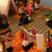
evancelt Posted January 14, 2021 (edited) Captain Brickleton wanted to know more about the island of Panarium. In the week following their arrival at the future site of Wullham, he sent expeditions out by land and sea to survey the island. Second Lieutenant Berthing of the 18th Hussars set out with another trooper and an Onondaga settler who had accompanied them from Elizabethville. They rode across the island many times identifying key features Most of the island was covered in grassy hills. They noted a total of ten mountains on the island and highlands on the northern half of the island. A medium-sized river flowed from the mountains of the southwest on to the sea. They spotted a few smaller islands offshore. Lieutenant Freeman, a Royal Navy Intelligence officer, circumnavigated the island by rowboat. Accompanied by a soldier of the 26th Foot, they spent a week camping on beaches and sounding the depths to establish the extent of the shallows. They made depth soundings around the island and took a detailed account of all of the inlets and shore curvature. They also were able to make out ten distinct mountains as they made their way around the island by sea. Once back at camp in Wullham, Lieutenant Freeman erected a table on a hill overlooking the sea. He had become close friends with his travel companion from the 26th Foot while conducting the survey. His friend and a second soldier played melancholy background music while Freeman combined the interior details the Hussars had gathered with his more detailed sea records. A detailed map of Panarium OOC: The accordion idea is from the BirdBase build by @Fraunces. Got some new CMF Series 21 minifigs in the mail yesterday and wanted to include the fiddle from violin boy in the third vignette. Edited January 14, 2021 by evancelt Cleaned up all of the images Share this post Link to post Share on other sites
Khorne Posted January 14, 2021 Wonderful builds and beautiful maps. I love how you add a new piece to the map every time and the final product looks great. It looks like a proper Lego map. Is the shape based on the Pirate maps? Nice work! I love the compass on the map as well. Did you draw everything in Illustrator? Share this post Link to post Share on other sites
CapOnBOBS Posted January 14, 2021 Outstanding map, great vignette for a new settlement. How did you make the map Share this post Link to post Share on other sites
evancelt Posted January 14, 2021 (edited) Thanks guys! I discussed with Ayrlego whether or not to make a standard BOBS color map of Panarium or a stylized one like this. After checking out the parchment-colored one for Cascadia, I ended up going with a style similar to that in order to fit it into the narrative of some vignette builds! In Illustrator, I started by zooming into the map Ayrlego had created: I did a quick-ish vector Pen tool trace of the island shape and then scaled it up to fill the artboard. I scaled the MILES scale at the same time to keep the scale the same. Next I grabbed some Pirate map elements from free vector websites (hills, mountains, compass rose) and built out the final map on a parchment background. Then I made two versions of it for land and sea where I deleted elements that were present in the final version. On the land map I simplified the island perimeter trace to have fewer anchors / make it a little more basic and also moved the islands out of place a little to simulate how someone on land would misjudge distances. Could be fun to add landmark builds on Panarium to it to show how they all fit together. @Khorne & @CapOnBOBS - Happy to share the Illustrator file / font if you want to base any other local maps on it. Edited January 15, 2021 by evancelt Share this post Link to post Share on other sites
Kai NRG Posted January 15, 2021 Lovely job on this map! Nice trio of vignettes too. Share this post Link to post Share on other sites
Bregir Posted January 17, 2021 Nice little vignettes to go with a good story. As others have said, the maps are out of this world. You really should be careful showing such skill! You'll end up being asked to do all our maps! Share this post Link to post Share on other sites
Khorne Posted January 18, 2021 On 1/14/2021 at 4:44 PM, evancelt said: @Khorne & @CapOnBOBS - Happy to share the Illustrator file / font if you want to base any other local maps on it. Thanks, that is very kind! I already have the font though, I think. It's called Pieces of Eight, no? I won't say no to the .ai-file however. Hoarding assets is always useful. Perhaps we can work it out via PM, so to not clutter this thread? Share this post Link to post Share on other sites
Fraunces Posted January 20, 2021 On 1/14/2021 at 5:50 AM, evancelt said: OOC: The accordion idea is from the BirdBase build by @Fraunces. Got some new CMF Series 21 minifigs in the mail yesterday and wanted to include the fiddle from violin boy in the third vignette. Thanks for mentioning me, I stole the idea too haha. Lovely violin indeed I was wondering where'd you got it. Great series of vignettes! Share this post Link to post Share on other sites